Frontera on the Front Lines During Record Hurricane Season
UT supercomputers enables emergency storm surge forecasts used by officials in Texas, Louisiana, and beyond.

Published on October 12, 2020 by Aaron Dubrow
The morning of October 9, 2020, the National Hurricane Center issued the following warning:
…RAINBANDS OF DELTA SPREADING INTO SOUTHWESTERN LOUISIANA AND SOUTHEASTERN TEXAS… …EXPECTED TO BRING HURRICANE CONDITIONS AND A LIFE-THREATENING STORM SURGE TO PORTIONS OF THE NORTHERN GULF COAST LATER TODAY…
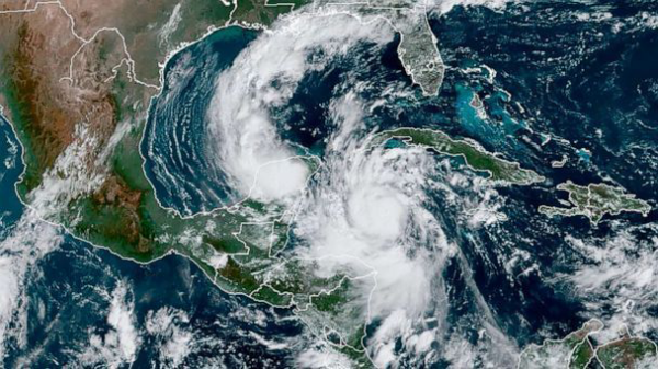
Days earlier, when Hurricane Delta was a small, disorganized storm in Caribbean Sea, the team of researchers who provide storm surge model guidance for coastal states were already cranking out simulations using the Frontera supercomputer at The University of Texas at Austin’s Texas Advanced Computing Center (TACC) — one of the fastest in the world.
Storm surge, the rise in sea-level caused by wind and waves, is the deadliest aspect of a hurricane. It can cause water levels to rise quickly — sometimes several feet in just minutes. Storm surge was the main cause of death during Hurricane Katrina and was a major factor in the devastating flooding of Hurricane Harvey.
Researchers have developed a system of computer programs called ADCIRC that use mathematical models of physical forces to simulate and predict the storm surge an incoming storm will produce based on the official hurricane forecast tracks. It has successfully forecast storm surge for the past 25 years.
“We’ve added more and more physics, better numerical algorithms, better software, better use of high performance computing resources, and it just continues to improve to the present day,” said Clint Dawson, professor of aerospace engineering and engineering mechanics at The University of Texas at Austin, leader of the Oden Institute Computational Hydraulics Group, and one of ADCIRC’s lead developers.
The ADCIRC Surge Guidance System uses supercomputers to recalculate and update the ADCIRC projections every time a new forecast advisory is issued. And in 2020 — with 25 named storms and nine hurricanes — that has been often.
During tropical storms, TACC provides the ADCIRC team with emergency access to supercomputers to accomplish the massive amounts of computing needed to derive answers in a highly compressed timespan. TACC has been a contributor to storm surge forecasting efforts for every major storm since Hurricane Ike in 2008.
Frontera at the Front
With each new supercomputer, storm surge forecasts improve. Since Frontera launched in September 2019, the team who oversees ADCIRC and CERA (Coastal Emergency Risks Assessment) — an interactive web mapper where ADCIRC forecasts are shared — have adapted their forecasting system for the new machine.
“Having Frontera available is incredible,” said Jason Fleming, principal consultant for Seahorse Coastal Consulting and lead developer and operator of the ADCIRC Surge Guidance System. “Frontera not only has more processors, but also faster processors, which allows us to do so much more.
“Urgent computing forecasts get stale very quickly. Forecasts needs to be ready in time for a leaders’ morning briefing, and if they come late, they’re not actionable.”
Until this year, it would take the ADCIRC team an hour to run one scenario or forecast. But on Frontera, they can run three scenarios in the same amount of time. “This provides better guidance to decision-makers,” Fleming said.
Precision in Measurement and Modeling
When tropical storms begin to form in the Atlantic, it kicks off a multi-stage process to ultimately deliver forecasts to emergency managers and the public. The ADCIRC Surge Guidance System automatically ingests the storm track and wind forecasts from the National Hurricane Center (NHC) every six hours. Based on wind data, ADCIRC creates an approximation of the wind conditions across the entire region, which is important for determining the storm surge.
The ADCIRC software then calculates the track and strength of the waves and winds, and unleashes them on the virtual coastline. This is represented by a series of meshes that show the underwater depth and terrain of the coast and near-shore land, and represent the large geographic area using smaller discrete cells.
These meshes — created by the Army Corps of Engineers, FEMA, and other parties using hydrographic surveys, navigation charts, and Light Detection and Ranging (LiDAR) data — contain millions of points and help show exactly where waters will rise and by how much.
Frontera is the largest of a handful of supercomputers used to compute ADCRIC forecasts. TACC’s Stampede2 and Lonestar5 systems are also used, as is Louisiana Optical Network Initiative Queenbee3 and systems that are part of Renaissance Computing Institute at UNC. Using multiple supercomputers provides a backup if one experiences a glitch. It also allows the team to model more scenarios simultaneously. These include alternative storm tracks, as well as predictions using different storm models.
The results of the simulations are fed to CERA, where they are converted into a visual map and annotated with useful information — for instance, real-time tide and river gauge data to show how forecasts relate to conditions on the ground.
The CERA site is a key source of guidance for emergency managers and decision-makers from Texas to Maine. It joins forecasts produced by the National Oceanic and Atmospheric Administration (NOAA), NHC and others, and helps inform decisions about about asset protection, impacts to critical infrastructure including energy, chemical, utility, and transportation, and the placement of supplies or first responders.
“Search teams doing search-and-rescue need to know where to stage strike teams to be close to an event, but not inhibited by consequences of high winds and high water,” said Gordon Wells, a researcher at UT Austin’s Center for Space Research and the university representative to the Emergency Management Council that advises Texas on storm response. “ADCIRC forecasts help us define the threat geography. What is the extent of the area that will be experience severe weather? We need to get a solid representation of those deterministic impacts.”
In the case of Hurricane Laura — which made landfall as a Category 4 hurricane near Cameron, Louisiana on August 27 — there was a possibility the storm would push water up the Neches River and impact levee structures.
“ADCIRC gave us confidence that we weren’t going to have problems there because of the wind,” Wells said. “There was no need to use resources, recommend unnecessary evacuations, or do house-by-house searches.” Preserving these resources allowed them to be utilized elsewhere.
Bigger Meshes for Better Forecasts
The ADCIRC model offers information and insights that other models do not. For instance, it is the only model that include the latest meshes of Texas, Louisiana and Florida, allowing predictions that are three times more resolved than those used by NOAA. (For Texas, the mesh contains 5.5 million vertices).
Since Frontera launched in September 2019, the team who oversees ADCIRC and CERA (Coastal Emergency Risks Assessment) — an interactive web mapper where ADCIRC forecasts are shared — have adapted their forecasting system for the new machine.
“The meshes are a huge improvement in terms of resolution and contain nitty-gritty details of every channel and bay,” said Carola Kaiser, lead software developer for the CERA website. “It’s really doing a great job. But if you have better input data, the calculations also get bigger, and you need more computational power to compute it. So, Frontera came online right on time.”
Another key feature of the system: The ADCIRC model can be adapted and improved upon even in the midst of a storm. Leaders can, and often do, ask the ADCIRC team to forecast slightly different scenarios. These can be added to the workflow and generated rapidly.
“When the people we’re advising ask questions, or want other information, we can do that,” Fleming said. “We can run it in real-time and turn a forecast around and give them the information they need.”
“If you’re going to create forecasts in near-real time and get an operational product to make meaningful decisions, the only way is to use supercomputers,” Wells said.
TACC’s resources are also critical for transferring data from satellites, sensors, and aircraft directly back to the NOAA processing center.
“The computing power, expertise, and support we get from TACC — there’s no way we can do this without them,” Fleming said.
“In the end, it’s not just a technical exercise,” Carola said. “This work really saves lives.”
Media Contact
University Communications
Email:
UTMedia@utexas.edu
Phone: (512) 471-3151